We’ve passed the wide mouth of the Potomac river on many cruises up and down the Bay, but never ventured up the almost 100 miles to Washington, DC. Intrigued by the river’s history and size, we wanted to poke into places we hadn’t been and visit the nation’s capital by boat from our home port of St. Michaels on the Eastern Shore.
It was a mild and sunny May morning as we rounded Point Lookout in calm winds and flat seas heading up the Potomac River. Our interest in the Potomac piqued after reading John Page Williams’
Chesapeake: Exploring the Water Trail of Captain John Smith. At the ripe old age of 28, Smith and his crew of 14 rowed and sailed their Discovery Barge up these same waters in search of a mythical Northwest Passage to the Pacific. They were hoping to find gold and silver for the Virginia Company, who sponsored their summer explorations of the Chesapeake Bay in 1608 and 1609 from their settlement at Jamestown. Clearly ours were less lofty goals.
As we rounded the point, we looked for the Potomac River buoy of the National Water Trail, one of six on the Bay. The bright yellow smart buoys from NOAA serve as interpretive guideposts for recreational boaters to learn about the diverse heritage and ecosystems of the Bay. There it was, bobbing in the water at the coordinates we found on their website. We called the 800 number posted on the buoy and followed a string of prompts to learn about the history of Smith’s voyage along with sea conditions, and other data and observations. What an innovative way to get information.
While several watermen worked their lines of colorful crab pots, we wove our way through the field and headed to the mouth of St. Marys River to anchor at Horseshoe Bend for the night. Since it was early in the season, the hospitality dock (2 hours) at St. Mary’s College was open so we tied up and went ashore to explore Historic St. Mary’s City, an outdoor living history museum preserved as a 17th century archaeological site. Just a short walk up the road from the college we entered the site and roamed through the streets of the busy first capital of the Maryland. Along the way we saw “ghost frames,” or wooden outlines of buildings at their original locations. The stark frames conveyed a sense of size and scale of the structures and community of this early settlement. As we strolled by Smith’s Ordinary, a group of third graders listened to an interpreter explain that an Ordinary was lodging for ordinary people, not the “high born gentlemen” of the settlement.

We followed a path down the high bluff to the river with a flock of kids who learned about the working ship and its seagoing days at the
Maryland Dove, a recreation of a 17th century square rigged ship on the river. We took advantage of the college WIFI and got email while an interpreter explained how early settlers churned butter and used bows and arrows to hunt. We marveled at the contrast in our lives today and those of the early colonists.
Setting out the next day to the Virginia side of the wide lower Potomac we saw the mouth of the Yeocomico River across the river. We headed further up river until we found Nomini Bay. The channel was well marked so we wound our way into the creek of the same name to drop the hook where the Nomini Indian Chief and his people shared a feast with John Smith and his crew. While we had the creature comforts of home on
High Life, our 36-foot trawler, it was hard to imagine the living conditions and exposure in Smith’s 30-foot open boat.
Going upriver the next day we noticed the shore of Maryland was dense with forest while the Virginia shore on the lower Potomac was high and broad-shouldered with houses perched on top of them.
We stopped to visit Colonial Beach, a nice protected harbor known in early days for its oyster wars with Maryland watermen, and later as a gambling haven. The town, a peninsula surrounded by the Potomac on one side and Monroe harbor on the other, was a summer beach resort. Today it’s a golf cart town with marinas and charming cottages on tree-lined streets. A local told us the town’s population grew with full time residents after World War II when a government munitions plant was built nearby. We spent an afternoon bopping around in a golf cart learning the intricacies of driving on the road with car traffic, quite a change from the controlled paths of a golf course.

As we cruised up the Potomac we fought a pesky tide and current most of the way, but navigating the well-marked river was easy. Gene found that we could pick up a half knot or so by hugging the shore and keeping out of the deeper faster moving water. We passed the Naval Proving Grounds on the Virginia shore and went under the Highway 301 bridge. The river takes a sharp turn to port after the bridge and Port Tobacco, a popular anchorage, before it dips down and heads almost straight north running wide and deep.
On the Maryland shore about 30 miles from Washington sat a rusty wreck guarding the fleet of “ghost ships” sunk at the bottom of Mallows Bay, a dumping ground for old war steamships and other derelict vessels. The site, considered to be the largest shipwreck fleet in the Western Hemisphere, has its positive side, having created a giant artificial reef, a habitat reclaimed as a nesting place for birds, fauna, and fowl.
The rivers narrows as it pushes north beyond Quantico Marine Corp Base where we encountered our first sights and sounds of civilization – helicopters and airplanes. Soon after the river narrowed we saw the impressive Wilson Bridge with its upside down white triangular base and roadway straight ahead.
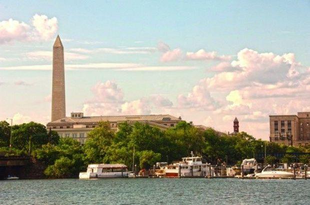
It was the Friday afternoon of Memorial Day weekend as we passed under the bridge and entered the maelstrom of Alexandria tour boat traffic. A no wake zone kept the commotion in check as we studied the chart looking for markers to lead us to the Washington Channel for our stay at Gangplank Marina. We were wide-eyed tourists looking at the steady stream of airplanes lifting off and landing at Reagan National, and we couldn’t take our eyes off the National Monument dead ahead of us as we made our way to the Anacostia River cutoff where we veered off to the marina channel.
Editor’s Note:
In April 2014 construction began at Gangplank Marina so the dockmaster said transient space is limited.

We were among the throngs of visitors including hundreds of bikers participating in the Rolling Thunder festivities, so we saw the merit of traveling sans auto. We used the DC Circulator, a $1 bus service that, along with the Metro, took us everywhere we wanted to go.
We visited some of the Smithsonian museums and were enchanted with the exhibits. In Georgetown we were part of the casual commotion on M Street enjoying breakfast at an outdoor café and took a ride on the Chesapeake and Ohio Canal on a canal barge pulled by mules and led by period-costumed guides from the National Park Service. For a short time in our country’s history canal travel was a main link between major East coast cities only to be replaced by the coal-driven railroads. Ironically it was the canal boats that hauled the coal that fueled them to the train lines.
It was a short trip by bus to the Metro and on to Alexandria where we hopped on the trolley and rode down King Street to the water. The Torpedo Factory at the foot of the river is a converted factory that made submarine and aircraft torpedoes until the end of World War II. Today it’s three floors of open studios and galleries where artists work and sell their art overlooking the Potomac. Nearby is the city marina docks and wooden boatbuilders at the Alexandria Seaport Foundation.
We rode the water taxi across the river to see the marina at National Harbor, the massive complex we passed on the Maryland side of the river near the Wilson Bridge. Then had lunch and walked the shops of the Gaylord National Resort & Convention Center overlooking the marina.

As we slipped our lines to leave the marina and head home, many of the liveaboards there were going to work in the District. We anchored our way down the Potomac in light winds until a cold front arrived and dark clouds filled the sky with 30 knots of an east wind that wouldn’t let up. The worst was at the mouth of the St. Mary’s River where the opposing forces of wind and current made for a most uncomfortable ride.
We made a quick decision to head into the wide mouth of the familiar St. Marys and duck into Indigo Creek. We followed a large sailboat past the Coast Guard station and dropped the hook to wait out the weather. The holding was good and our anchor set right away against the strong winds. Surprisingly we were in a WIFI hotspot and enjoyed an Internet connection thanks to a shoreline homeowner who left their wireless connection open. The only casualty was our shredded Miles River Yacht Club burgee.
As we left the Potomac River a thick fog burned off by mid-morning and the seas were down to a foot or less. We were uncomfortable for a few hours the day before, but we wondered how would Smith and his crew survive in such a small boat in such high winds? He went on to explore and document his findings with drawings and observations of the Bay rivers and we like to think we’ll follow in his wake, but in a more comfortable boat.
by Katie & Gene Hamilton It was a mild and sunny May morning as we rounded Point Lookout in calm winds and flat seas heading up the Potomac River. Our interest in the Potomac piqued after reading John Page Williams’ Chesapeake: Exploring the Water Trail of Captain John Smith. At the ripe old age of 28, Smith and his crew of 14 rowed and sailed their Discovery Barge up these same waters in search of a mythical Northwest Passage to the Pacific. They were hoping to find gold and silver for the Virginia Company, who sponsored their summer explorations of the Chesapeake Bay in 1608 and 1609 from their settlement at Jamestown. Clearly ours were less lofty goals.
As we rounded the point, we looked for the Potomac River buoy of the National Water Trail, one of six on the Bay. The bright yellow smart buoys from NOAA serve as interpretive guideposts for recreational boaters to learn about the diverse heritage and ecosystems of the Bay. There it was, bobbing in the water at the coordinates we found on their website. We called the 800 number posted on the buoy and followed a string of prompts to learn about the history of Smith’s voyage along with sea conditions, and other data and observations. What an innovative way to get information.
While several watermen worked their lines of colorful crab pots, we wove our way through the field and headed to the mouth of St. Marys River to anchor at Horseshoe Bend for the night. Since it was early in the season, the hospitality dock (2 hours) at St. Mary’s College was open so we tied up and went ashore to explore Historic St. Mary’s City, an outdoor living history museum preserved as a 17th century archaeological site. Just a short walk up the road from the college we entered the site and roamed through the streets of the busy first capital of the Maryland. Along the way we saw “ghost frames,” or wooden outlines of buildings at their original locations. The stark frames conveyed a sense of size and scale of the structures and community of this early settlement. As we strolled by Smith’s Ordinary, a group of third graders listened to an interpreter explain that an Ordinary was lodging for ordinary people, not the “high born gentlemen” of the settlement.
It was a mild and sunny May morning as we rounded Point Lookout in calm winds and flat seas heading up the Potomac River. Our interest in the Potomac piqued after reading John Page Williams’ Chesapeake: Exploring the Water Trail of Captain John Smith. At the ripe old age of 28, Smith and his crew of 14 rowed and sailed their Discovery Barge up these same waters in search of a mythical Northwest Passage to the Pacific. They were hoping to find gold and silver for the Virginia Company, who sponsored their summer explorations of the Chesapeake Bay in 1608 and 1609 from their settlement at Jamestown. Clearly ours were less lofty goals.
As we rounded the point, we looked for the Potomac River buoy of the National Water Trail, one of six on the Bay. The bright yellow smart buoys from NOAA serve as interpretive guideposts for recreational boaters to learn about the diverse heritage and ecosystems of the Bay. There it was, bobbing in the water at the coordinates we found on their website. We called the 800 number posted on the buoy and followed a string of prompts to learn about the history of Smith’s voyage along with sea conditions, and other data and observations. What an innovative way to get information.
While several watermen worked their lines of colorful crab pots, we wove our way through the field and headed to the mouth of St. Marys River to anchor at Horseshoe Bend for the night. Since it was early in the season, the hospitality dock (2 hours) at St. Mary’s College was open so we tied up and went ashore to explore Historic St. Mary’s City, an outdoor living history museum preserved as a 17th century archaeological site. Just a short walk up the road from the college we entered the site and roamed through the streets of the busy first capital of the Maryland. Along the way we saw “ghost frames,” or wooden outlines of buildings at their original locations. The stark frames conveyed a sense of size and scale of the structures and community of this early settlement. As we strolled by Smith’s Ordinary, a group of third graders listened to an interpreter explain that an Ordinary was lodging for ordinary people, not the “high born gentlemen” of the settlement.