I got the idea from my friend and patient Ed. One day he was seated in my operatory chair, and besides getting some dental work done, we were talking about a topic dear to us both: messing about in boats. “Wouldn’t it be fun to launch your boat somewhere around New York Harbor and spend a day there exploring?” we mused. Of course! It would make for a memorable day on the water; that’s for sure. At the time I didn’t have a boat suitable for such a mission, and there were other things grabbing my immediate attention, but I sure was intrigued.
A few years later I was on the New Jersey shore in Sandy Hook, exchanging a handful of cash for a well-used Hobie Tiger catamaran. Since I couldn’t understand very well the seller’s thick French accent as he explained the nuances of the boat, he lost me a little. My mind drifted, and I gazed out over the water. I was amazed to make out the New York City skyline in the hazy distance, some 25 miles away. I knew right away that this would be the ideal place to launch the boat for the New York harbor cruise one of these days.
The Dream and the Prep
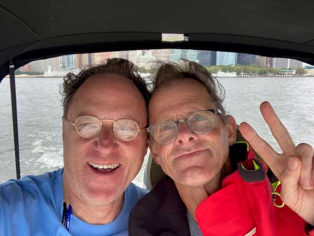
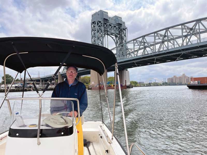
More time elapsed, more scheming in the deep recesses of my mind on the details of such a trip. Finally, the Manhattan Island Circle was at the top of the docket. I had the boat—a 17-foot Boston Whaler Montauk—I had the time, and I had a willing and able partner in my close friend Eric Bourhill. He was as enthusiastic about “the mission” as I was.
The basic idea was to spend a late summer day exploring New York Harbor, circumnavigating Manhattan Island in the process, and maybe Staten Island, too. As per usual, I completely nerded out on the planning. I pored over maps, nautical charts, and satellite images. I studied the internet for helpful data of all kinds.
It was hoped, of course, that fair weather would coincide with the days we had carefully scheduled for the trip, but in order to ensure that the endeavor would actually occur, we had to plan for an acceptable level of inclement weather. Tempestuous conditions for the southern part of the route would be a significant factor since that 20-mile passage to Verrazano Narrows is wide open to the Atlantic Ocean. So, we hoped for the best while packing the foul weather gear and placing everything in waterproof bags.
We gave our vessel, Go-Cat, a thorough going over and equipped it with an assortment of spares and tools, additional lines, multipurpose bucket (Porta Potti?), ship’s documents, paper and digital charts, and the aforementioned foul weather gear. Besides the 25 gallons of fuel in the main tank, we carried two additional five-gallon jugs of it.
We packed water and food for a long day on the water in a cooler-seat, and we brought plenty: cans of beans (of course) and tuna fish, crackers, peanut butter, cheese, cookies, apples, oranges… We would not be going hungry.
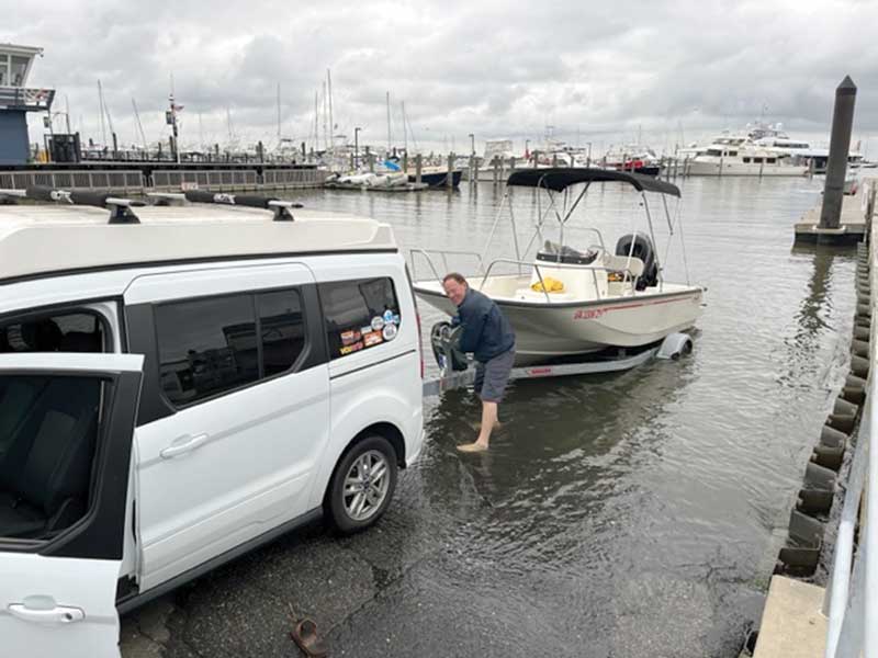
The plan involved trailering Go-Cat from her home port of Locklies Creek in Middlesex County, VA, to the launch ramp at Atlantic Highlands, NJ. As you can imagine, the terra firma part of the trip, driving to and from New Jersey, required careful consideration in and of itself. After all, it’s about 400 miles each way through some of the most congested roads on the Eastern seaboard. Pulling 3000 pounds of boat and trailer with a little Ford van (the “Buggy”), barely adequate for the job, would be exciting if not a little nerve wracking.
In an effort to minimize roadside shenanigans, we fully serviced the Buggy and the trailer. We equipped ourselves with a spare tire for each, a three-ton capacity floor jack, air compressor, and tools.
Captain’s Log: It’s Go Time
It’s August 28. Go time arrives at the appointed hour of 3 a.m., which we hoped would be early enough for us to miss some of the heavy traffic and get us to the launch ramp by 10 a.m. The long drive goes as expected and wished for: uneventful, with the traffic heavy but manageable. The sky is grey, but rain was not in the forecast. We’ll take it!
My research paid off, as ever, making for quick negotiation of the launch ramp check-in procedure. In just a few minutes Go-Cat is in the water and tugging at her lines. We are ready. Even the grey sky can’t dim our enthusiasm. We motor out beyond the breakwater and throttle up. Before long Go-Cat is leaping and frolicking in the lumpy seas on our way north.
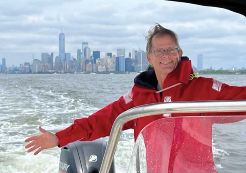
The Big Apple skyline comes into focus as the miles fall in our wake. We howl and hoot as we pass under the Verrazano Narrows Bridge, raising our arms in celebration as we enter New York Harbor proper. As we find ourselves increasingly in the realm of NYC, things get that much more interesting. “There’s Staten Island! There’s the financial district of Manhattan! There’s Ellis Island, and Governor’s Island, and the Statue of Liberty!” we shout.
We head directly to the proud, torch-thrusting woman with her unmistakable shroud of verdigris. Oh my, the romantic in me has a fit. We notice that the island at the base of the statue is crawling with ant-sized people. We wave, smug and happy to be touring aboard what is essentially our private yacht. Moving on, past Ellis Island, we’re amazed at the scene. Our heads are kept swiveling not only due to all the dry land points of interest but the crisscrossing ferry boat traffic as well. It’s difficult to keep up with them all, from the huge Staten Island ferries to all the smaller ones zipping about. The harbor seems to be perpetually churned up into waist high waves coming from all directions. Go-Cat handles it just fine, but we are not surprised to find that we are pretty much the only recreational vessel out here. We do see a stately old ketch motoring up the East River in the midst of all the confusion. Its equally stately skipper seems unmoved, sedately smoking a pipe and resting one finger on the tiller.
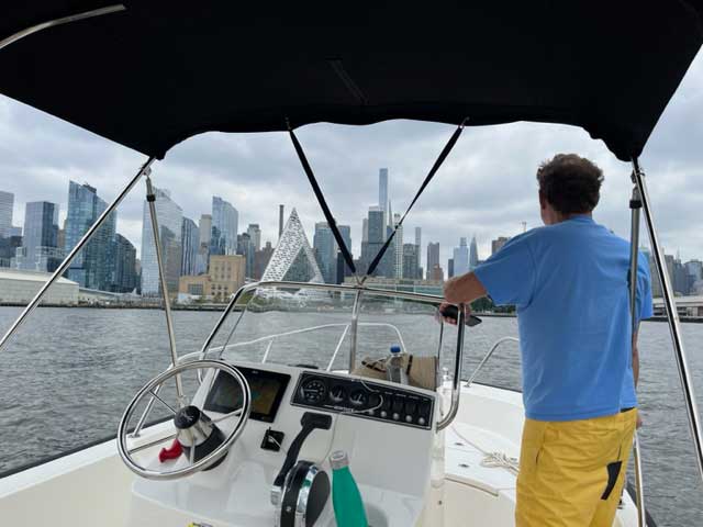
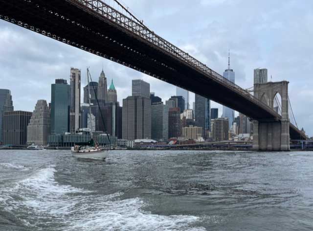
Our Manhattan Island circle proceeds in a counterclockwise direction. We head up the East River, leaving the Battery and then the City Seaport on our port side. We pass under the legendary Brooklyn Bridge, and soon leave the heavy ferry traffic behind. We slow Go-Cat to five knots or so and gawk right and left as we make our way up the waterway.
Frank Sinatra is singing lustily in my head, “New York, New York!” There is just so much to see; I can barely take it in. We are continually amazed at the seemingly endless variety of the city’s architecture. From the grand, century-old buildings to the new cutting-edge ones.
The building of these skyscrapers really took off in the 1920s. The German architect Erich Mendelsohn wrote during that time that Manhattan had become, “the harbor of the world, messenger of the new land.” The New York Times reported in 1929 that skyscrapers had, “become to the whole of these United States a symbol, a fashion and a heaven-climbing contest.”
Here on the east side, we have a great view of the fabulous art deco Chrysler Building, designed by architect William Van Alen. It was completed in 1930 and ushered in an exhilarating new era of high-rises. Today the Chrysler seems dwarfed among a forest of titans, including of course the 1250-foot Empire State Building, completed in 1931.
Seeing the skyscrapers from the water, as opposed to viewing them from within the urban canyons is especially spectacular; one can appreciate the individual character of each structure so much more.
We pass under the Manhattan Bridge, the Williamsburg Bridge, and the Roosevelt Island Tram. We’ve passed Brooklyn; now it’s the borough of Queens that’s off to starboard.
The East River turns to the northwest and narrows considerably as it becomes the Harlem River. Now the Bronx lies to starboard. We slow down another notch. The eye-opening wild magic of New York continues. There are parks, luxury residences created from various old structures, homeless encampments. There are sections of the river that are obviously integral to the life of the city, and there are sections that seem totally forgotten. We see a few fishermen, but surprisingly we have the Harlem mostly to ourselves. We pass under more bridges—18 of them before we return to The Battery—and we marvel at the graffiti, the street art, adorning them. We munch our delicious lunch feast as we putter along. The clouds part and the sun makes the window glass of the city shimmer.
At the “top” of Manhattan, the Harlem River meets the Hudson. High cliffs at this juncture are painted with a giant “C.” Yay, Columbia University! A low railroad bridge bars our access to the Hudson. Lowering the sun top of Go-Cat allows us to sneak under and ease into the wide Hudson where we hang a left and head south again. We cruise down the river at 18 knots, our curiosity aroused by first one bank and then the other. We pass under the George Washington Bridge. We muse about how Captain “Sully” Sullenberg managed to safely put down that big Airbus A320 on this part of the Hudson. Wow.
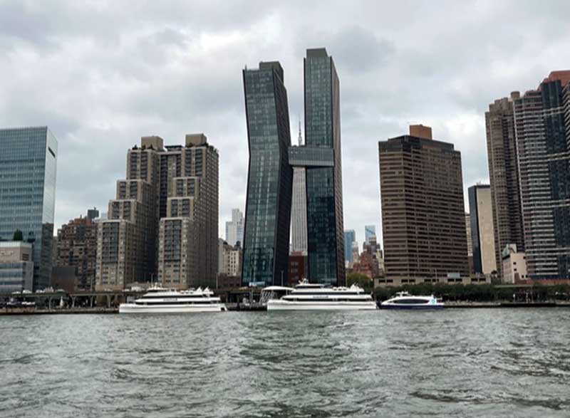
Hoboken and Jersey City lie off to the west, and on our left we love seeing the cool buildings of south Manhattan come into view again. They all seem to be trying to outdo each other in terms of architectural flair. We’re blown away by yet another certain skyscraper, the tall and slender residential tower by SHoP Architects. When I say “slender” I mean super skinny! It’s 1428 feet high and has a height to width ratio of an incredible 24:1. Eric and I just shake our heads in delight.
Continuing south we pull in close, poking our bow into irregularities in the west side shoreline where docks project and vessels of all kinds are moored. We wave at the people walking along the promenade in Rockefeller Park. Nearby, the 100-story Freedom Tower pokes up its shining head.
Meanwhile, the good ship Go-Cat is running perfectly. Breaking down in the waters of New York City would be most inconvenient! And the weather holds. Mostly overcast with occasional bouts of sunshine. No rain, light breeze.
We still have several hours of daylight left on this long day, enough we figure to go around Staten Island on our way back to Sandy Hook. We wave at the Statue of Liberty as we head south away from Manhattan and enter the waterway separating Staten Island from New Jersey. On the nautical charts this part of the route is Bergen Point West Reach. The heavy industry of oil refining welcomes us on the Bayonne side, and as we continue on, we remain fascinated by all the industrial activity that we see. On the Staten Island side are maritime works such as shipyards and huge dry docks to service vessels like Staten Island ferry boats. On the New Jersey side are scrap metal yards and container ports, and besides those are petroleum works.
And this Staten Island loop features what Eric and I especially love: tugboats of every size, shape, and description. A couple of them are towing and cajoling a large passenger ship to one of the scrap yards. We stay out of their way. Like excited five-year-old kids we watch three super-size cranes with giant claws transfer scrap metal from a soaring pile on land onto a waiting barge tied alongside.
We poke into a side bay studded with the half-sunken, abandoned, rusting steel hulks of once-proud commercial vessels. I’m thinking, ‘wow, it doesn’t get any better than this.’
Suddenly, Go-Cat lurches and we hear an awful screech from the engine. We hit something submerged, hard, and immovable. Part of one of those rusting hulks, I guess. Ugh. We stop and tilt the outboard. I squint my eyes, afraid of what I might see. The prop looks okay but there are scratches and a large bite out of the leading edge of the lower unit. Will it keep running well enough to get us back to Atlantic Highlands? We cautiously proceed. The trusty 115 Mercury seems to run okay, but I wonder about that newly acquired groan emanating from it.
The waterway around Staten Island isn’t all lined with heavy industry; we motor past the residential waterfronts of Carteret and Sewaren. And on the Staten Island side are vast green spaces such as Islands of Meadows. At Perth Amboy, home to an inviting waterfront park, we come to the south end of Staten Island. At this point we head east and emerge into the open water of Raritan Bay. We set a course for Atlantic Highlands, 18 miles farther and the end of the day’s voyage.
A stout east wind has come up. It will be slow going against it and the head seas it’s generated. The sky has turned a somber grey. We hunker down in our foul weather gear.
We’ll make it back to the boat launch by nightfall. By then we’ll have totaled over 80 miles under Go-Cat’s keel for the day. The motor will run well enough to get us there; to be repaired properly back home later. We’ll be exhausted as we winch the boat onto the trailer and head out for tacos and a hotel room for the night. We’ll take on the 400-mile drive home tomorrow.
And during that journey, besides debriefing over the New York adventure, you can be sure we’ll be planning for the next one.
By John W. Robinson