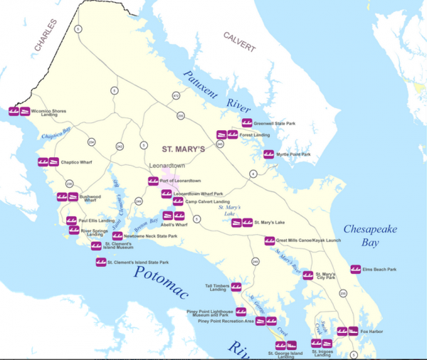
Access. It’s what we all want, whether it’s to our congressman, our boss, or the Bay. When it comes to getting out on the water, we want it fast and easy too. While the Internet has made searching for boat ramps and other launch sites much easier, we’ve pulled together the following resources to help get you off your electronics and out on the water as quickly as possible.
Want to launch in Maryland? Start with the online water access guide at
dnr.maryland.gov/boating/boatramps, which lists boat ramps, soft launches, and site details by county. Click on the site name for details such as fees, permits, hours of operation, parking, and contacts. Because most public access sites in Maryland are managed and maintained locally, fees and permits may vary. For specifics, contact the local entity before you go.
In Virginia, go to
dgif.virginia.gov/boating/access. You won’t find the same interactive map fun, but boaters can easily locate ramps by body of water, county, or city and view each location through a link with Google Earth.
Boaters can also check their local jurisdiction’s website for access information. For example, Anne Arundel County, Maryland’s Department of Recreation and Parks has a Cartop Boat Launch program site that includes information on location, number of parking spaces, permit information, hours of operations, contact phone numbers, fees, park amenities, and more:
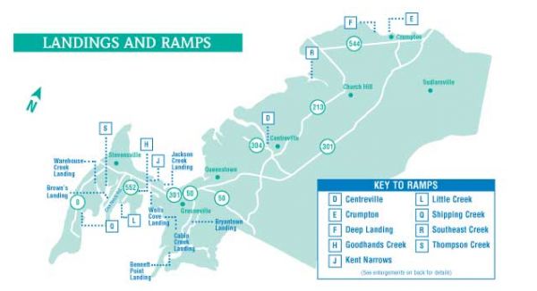
aacounty.org/recparks/launch. Likewise, Queen Anne’s County, MD, maintains a user-friendly webpage of public landings and ramps that includes a map and written directions:
parksnrec.org/directions-to-qac-public-landings. Similar information can be found for Cecil County, MD, at:
cecillanduse.org.
Public parks may be the most cost effective places to launch your craft, but they’re not your only option. Many private marinas allow the public to use their ramps for a relatively small fee. Two examples are LJ Marina on Mill Creek and Smith’s Marina on the Severn River. Before hitching up the trailer and loading up the water toys, call ahead, especially on busy summer weekends, because slips and parking can fill up fast.
For access around the Bay or around the country, another good resource is the BoatU.S. ramp locator at
boatus.com/ramps, where you’ll find information by state or on an interactive Google map. There you’ll also have access to fun photos and helpful comments posted by fellow boaters.
Would you like to see more public access? Many groups around the Bay are
actively working to increase public launch points and landings. A few such organizations are the Chesapeake Conservancy,
chesapeakeconcervancy.org, the National Park Service and its partners, Friends of the Chesapeake Bay Gateways,
baygateways.net, and Friends of the John Smith Trail,
smithtrail.net.
Anglers, paddlers, and boaters are also active at the local level in organizations such as the Anne Arundel Public Water Access Committee,
aacounty.org/recparks/launch/water_access. Grassroots voices have been heard; in 2013 Maryland’s Governor O’Malley signed The Waterway Access bill into law, which seeks in part to increase access points under new bridge construction or bridge reconstruction.